

The first Wakefield RISC OS Computer Club (WROCC) meeting of 2024 will take place on Wednesday, 10th January – a week later than the regular date, which would have been the 3rd – and the guest speakers will be Matthew and Hilary Philips from Sine Nomine.
Search Results for: RiscOSM
RiscOSM 2.07 and Recce 1.06 both now on the map
Users of Sine Nomine‘s excellent mapping application RiscOSM, and its sibling application Recce, can now grab new versions of both pieces of software.
News bit: Zimbabwe map now available to use with RiscOSM
Bernard Veasey has made available another vector map, complete with contour data, for use with RiscOSM, this time of Zimbabwe.
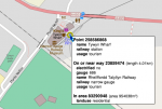
News nybble: RiscOSM gains contour lines in time for London
RiscOSM, the mapping software from Sine Nomine that uses data derived from OpenStreetMap has gained a major new feature in time for the London Show. Towards the end of his talk at April’s Wakefield Show, Matthew Phillips mentioned that Sine Nomine were looking at adding contour lines, the data for which is now available from Ordnance Survey under an open data licence. That feature has now been added – although, being data from Ordnance Survey, that does mean it’s only for Great Britain. Upgrades to the latest version, supporting contour…
News nybble: New version of RiscOSM at the London Show
Visitors to Saturday’s London Show will be able to see (and buy or upgrade to) a new version of RiscOSM, the map viewing software from Sine Nomine. The headline feature of the new version is the ability to trace out routes on the map – the software can now follow map features when doing so, making it easy to plan an accurate route. See it in action on Sine Nomine’s stand, or in the show theatre during Matthew Phillips’ presentation. Also check out Chris Hall’s GPS software, relaying location data…
RiscOSM 1.29 release at the London Show
Announcement from Matthew Phillips, 23rd October, 2015. Sine Nomine Software will have a new release of RiscOSM, the vector mapping software for RISC OS, available at the London Show. We will also have a selection of SD cards with fresh map data, covering the Americas, Australasia, Africa, and all the countries in Europe using the roman alphabet.
RiscOSM crosses borders at Wakefield
Map app gap snap! Sine Nomine Software, who should be on stand 18 in the Cypress Suite of Saturday’s Wakefield Show according to the provisional floorplan, will be bringing a new version of RiscOSM along to the event. The software, which uses data sourced and converted from OpenStreetMap, brings comprehensive mapping facilities to RISC OS, and was first launched at last year’s show.
RiscOSM update and special offer
Bugs squashed – easier than giving them a map and sending them on their way. Sine Nomine Software have released a new version of RiscOSM, their mapping software for RISC OS. Version 1.21 of the application, which uses map data converted from OpenStreetMap, is now available to download as a free upgrade for existing users.
RiscOSM 1.07 now available
Bridge? What bridge? Sine Nomine Software’s Hilary Phillips has announced a new version of RiscOSM. Version 1.07 allows the user to save the location under the mouse pointer, whereas previously the saved position was the middle of the map, and also fixes a few issues that could previously cause RiscOSM to either crash, or omit features from the map.
RiscOSM: new release
Announcement from Hilary Phillips, 11th July, 2014. Firstly, just to say that Sine Nomine Software will unfortunately not be attending the MUG Show this year: the previous information circulated was the result of a misunderstanding. We are pleased to announce a new release of RiscOSM, the vector mapping software based on OpenStreetMap data.